Back Home

Start making better decisions today, based on accurate aerial data

Start making better decisions today, based on accurate aerial data

  • Home
  • Services
  • News
  • Contact/Find Us
Home » The Best Topographical Surveys. » Spire-PDF-image-plus-CAD

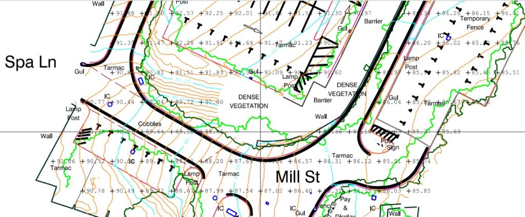
Spire-PDF-image-plus-CAD


← Previous Next →
http://www.aerialinspectionandmapping.co.uk/wp-content/uploads/2025/12/Spire-PDF-3-1024x424.jpg http://www.aerialinspectionandmapping.co.uk/wp-content/uploads/2025/12/Spire-PDF-image-plus-CAD-1024x428.jpg http://www.aerialinspectionandmapping.co.uk/wp-content/uploads/2025/12/Spire-Ortho-1-1024x468.jpg http://www.aerialinspectionandmapping.co.uk/wp-content/uploads/2025/12/Spire-PDF-1-1024x429.jpg http://www.aerialinspectionandmapping.co.uk/wp-content/uploads/2025/12/HM-3-1024x487.jpg http://www.aerialinspectionandmapping.co.uk/wp-content/uploads/2025/12/Spire-Ortho-2-1024x459.jpg http://www.aerialinspectionandmapping.co.uk/wp-content/uploads/2025/12/HM-1-1024x440.jpg

Leave a comment Cancel reply

Your email address will not be published. Required fields are marked *

This site uses Akismet to reduce spam. Learn how your comment data is processed.

Contact Us:

3, The Bridge Business Centre, Beresford Way, Chesterfield, Derbyshire S41 9FG 01246 268444

RSS AIMSurveys

  • SLAM vs VZ400i
  • The Best Topographical Surveys.
  • Photogrammetry or LiDAR
  • Measured Building Surveys.
  • Heritage Site Survey Solutions
  • Forest Mapping.
  • Best SLAM Surveys.
  • Reality Capture
  • Land Surveying Large Sites.
  • Cement Plant Surveys.

· © 2026 AIMSurveys · Designed by Press Customizr · Powered by ·