Back Home

Start making better decisions today, based on accurate aerial data

Start making better decisions today, based on accurate aerial data

  • Home
  • Services
  • News
  • Contact/Find Us

Handheld LiDAR No Shadows No Missing Bits

Handheld Mobile Mapping

Riegl VZ Scanner on Extending Tripod

Remote Access Surveying

Survey Grade Camera for High Resolution Photogrammetry

Detail 2D and 3D CAD from Scan Data

Photogrammerty to Ortho-Rectified image to CAD

Client Created Section from RiPANO

CAD Section from 3D Model

RiPANO Included with all Riegl Scan Data

Building Beam Layout CAD

‹
›
Home » Measured Building Surveys

Recent Posts

  • SLAM vs VZ400i
  • The Best Topographical Surveys.
  • Photogrammetry or LiDAR
  • Measured Building Surveys.
  • Heritage Site Survey Solutions
  • Forest Mapping.
  • Best SLAM Surveys.
  • Reality Capture
  • Land Surveying Large Sites.
  • Cement Plant Surveys.

Services

  • Aerial Surveys
  • Environmental Monitoring
    • Flood Monitoring
    • Land Slide Monitoring
    • Visual Impact
  • Forest Mapping and Mensuration
  • Highway Surveys
  • Infrastructure Inspection
    • Structural Monitoring
  • Measured Building Surveys
  • Photography and Filming
  • Railtrack and Infrastructure
  • Reality Capture
  • Underground Mapping Services
  • Visual Impact
  • Deep Mine Surveys
  • Development Site Surveys
  • Electricity Grids & Distribution Networks
  • Hydrographic Surveys
  • Landfill
  • Oil & Gas Distribution and Infrastructure
  • Opencast Coal
  • Quarry Surveys
  • Stock Surveys
  • Terrestrial Laser Scan Surveys
  • Topographical Surveying

Measured Building Surveys


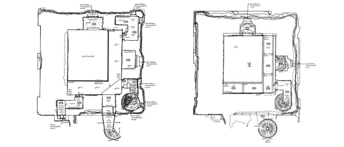
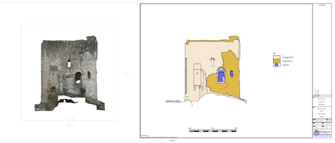
We create accurate, scaled technical drawings or 3D models of existing buildings.

Our professional surveyors, meticulously record the dimensions, layout, and architectural features of a building or structure. This provides a precise foundation for any future work on the property. 

Contact Us:

3, The Bridge Business Centre, Beresford Way, Chesterfield, Derbyshire S41 9FG 01246 268444

RSS AIMSurveys

  • SLAM vs VZ400i
  • The Best Topographical Surveys.
  • Photogrammetry or LiDAR
  • Measured Building Surveys.
  • Heritage Site Survey Solutions
  • Forest Mapping.
  • Best SLAM Surveys.
  • Reality Capture
  • Land Surveying Large Sites.
  • Cement Plant Surveys.

· © 2026 AIMSurveys · Designed by Press Customizr · Powered by ·