Aerial Inspection & Mapping Surveys Ltd is now a wholly owned subsidiary of Mining Surveys (UK) ltd.
![]()
The logo is just the first of our changes.
In line with MSUK philosophy of inovation and advancement in the field of geomatics and striving to increase safety in the workplace whilst keeping that keen competitive edge, we intend to introduce the very latest hardware and software into AIMS’ already sophisticated work-flow.
AIMS will now have all the backing of a successful surveying company with over 30 years experience.
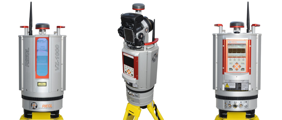
AIMS will have at it’s disposal the very latest GPS, Total Stations and the worlds number one Terrestrial Laser Scanning System.
AIMS can now offer a total survey and mapping solution. No more missed deadlines caused by inclement weather and no more missing data un-surveyable from the air.
AIMS recognised that use of full frame cameras was fundamental in achieving survey grade accuracy. It also recognised that only multi rotor UAV’s were capable of carrying this heavy payload and the limitations in battery life and flying times resulting in a multitude of flights required to cover large sites. It was clear there was a need for a fixed wing solution, like an Ebee but with full frame camera solution. AIMS undertook a Research and Development program aimed at filling this gap in the market.
AIMS succeeded in developing a big fixed wing solution called the “Bit Mapper”.
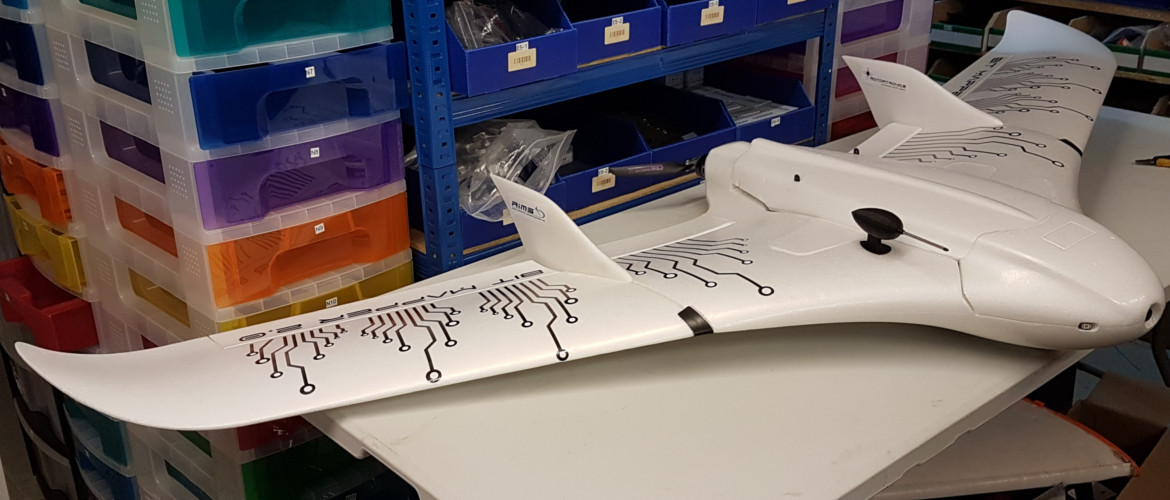
The Bit Mapper has up to 90 minutes flight time, approximately 700ha in a single flight, as compared to the Ebee which has 50 minutes and the Datahawk which has 45 minutes.
The Bit Mapper is fitted with the latest RTK system which is linked to a ground station which in turn has been fixed to OS grid and datum using survey grade GPS. The RTK system allows the images to be geo-referenced, this allows the software to align the images very quickly. Minimal GCPs are used to check accuracy of the survey but RTK does allow for a big reduction of GCPs from 35 to 5.
The Bit Mapper has auto take-off and landing with laser guidance, air speed indicator and reverse thrust coupled with the very latest Pixhawk flight controller providing fully autonomous flights and managing a wide range of intelligent fail safes. Because it is based on the Ardupilot open source software the flight controller can be regularly updated with the very latest innovations, at no additional cost.
Unlike the Ebee, the Bit Mapper is equipped with Sony RX100 camera on a gimbal for stability ensuring the camera is facing downwards whilst the aircraft is banking, to produce accurate survey grade 3D reconstruction.
At the time of the merger the R&D project was still in the development stage. We intend to continue until we find the solution, watch this space!