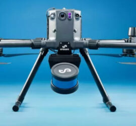
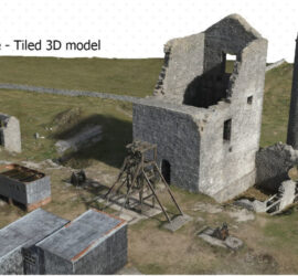
John Halifax


SLAM Scanning.

Introducing our latest acquisition, to improve efficiancy and reduce costs. The Hovermap ST. Keeping cost down is always important to us, terrestrial scanners like our Riegl Scanners the VZ1000 and the VZ400i are normally our go to tools and offer sub 5mm accuracy but they are static scanners, and they […]


3D Model data capture using Smart Oblique Image Capture

First Survey Grade Drone.

It’s time to retire our XR6, and invest in DJI’s first survey grade camera, for professional survey companies. It marked DJI’s first major entry into the dedicated drone photogrammetry market, expanding their offerings beyond other types of payloads.  Before the Zenmuse P1, other manufacturers offered advanced payloads for drone-based surveying. Including […]


AIMS take delivery of the 1st Wingtra One PPK in the UK

AIMS have now been operating the Wingtra One PPK for over 16 months surveying over 50 large sites around the UK. The Wingtra One PPK the safest and most accurate VTOL drone, for mapping and surveying. Combining vertical take-off and landing with long range flights, it carries the best in […]


AIMS Joins Mining Surveys (UK)

Aerial Inspection & Mapping Surveys Ltd is now a wholly owned subsidiary of Mining Surveys (UK) ltd. The logo is just the first of our changes. In line with MSUK philosophy of  inovation and advancement in the field of geomatics and striving to increase safety in the workplace whilst keeping […]